Family Day Hike at Sleeping Turtle Preserve North
Family Day Hike The Ligon Family Conservation Area: The North Side of Border Road
Located along Border Road in Sarasota County’s outskirts of Venice, lies Sleeping Turtle Preserve North. This gem of a park is great for bird watching, picnicking, and wildlife viewing. Choosing your own adventure from the many connector and cross over trails allows you to determine the length of your journey. The preserve is quiet and peaceful. Relax, reconnect, and forget your worries beneath the forest canopy.

Just past the Sleeping Turtle Preserve sign, is the parking area for both sides of the park. The preserve is split by Border Road, and there is a scenic loop trail on both sides. Each loop is about 1.5 miles in length. It is important to mention that leashed pets are only allowed on the North Side of Border Road which is the side where the parking area is located.
Just beyond the parking area is the beginning of the trailhead. A small interpretive panel presents a graphic display of the park. It encourages and beckons the hiker to explore the different areas of the preserve. There is also a clear kiosk dispenser where you can pick up a map at the beginning of the trail. There are many opportunities to alter the length of your trail making it suitable for all skill levels, and a different experience can be created on every visit. With so many options, we were happy we had a map because there were a few times we might have gotten lost without it. Trail maps are also available online at:
https://www.scgov.net/Home/ShowDocument?id=33599 .

As you begin to saunter down the unpaved, hard-packed trail, you will notice that blue trail markers are numbered on wooden posts and correspond with the locations on the map. Picnic benches, pavilions, and scenic overlooks are also clearly marked.

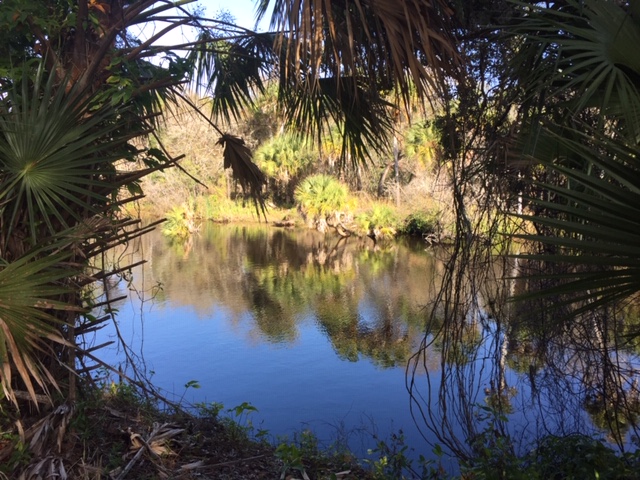
At marker 2, take a moment to enjoy the view from the bench perched above the tea-colored Myakka. This stop offers a great view of the sleepy and slow-moving river. Along the sandy banks, you may see a solitary gator or some turtles relaxing in the sun. Herons search for their supper and fish along the edges. On this bluff, an informative, interpretive sign is a visual magnet detailing the flora and fauna of the area. It offers an opportunity to pick up some informational tidbits that are nice-to-know, and it leaves you with a better understanding of the area.

As we ambled along, an unmarked foot path enticed us. We were led along the mellow and meandering river. Not far down the trail, we saw ropes swaying slowly from a tree perched near the water. While all was quiet on this chilly day, we mused that it must be a popular place to cool off during the tropical days of summer. Wandering a bit further, we were surprised by the turkey vultures feasting on a wild boar at the river’s edge: Nature in action and a clear reminder of the circle of life.
We continued under the shade of the moss-covered trees until we neared marker 9 and the kayak/canoe launch. This launch is the midpoint of the loop trail at about .7 mile. The covered pavilion beckoned us, and we decided it was a perfect spot for our picnic. This grassy area is a beautiful spot for hikers and paddlers to rest along their journey. You can easily hike the trail to the boat launch and back in about an hour, but the launch is much too far away from the parking area to be a convenient starting point for the beginning of a paddle.

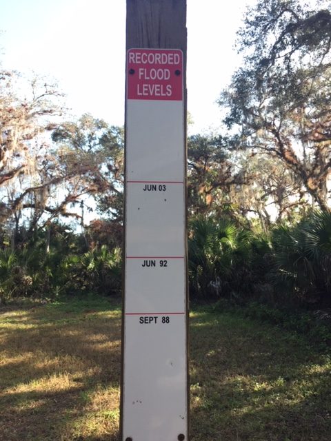
Located near marker 8, is another picnic pavilion that is adjacent to the slow-moving Myakka. A wooden column displays the flood level history. This post lists all the depths and dates that the area has been covered with water. Just like the marks on a door frame measuring a child’s growth, children can stand next to this marker and compare their height in relation to the flood markings. Our son was pleased to note that he measured a bit taller than the flood of September 2001, but was not quite as tall as the flood of September 1988.
Slowly we made our way back to the parking area. As we passed markers 12, 13 and 14, the area opened up to a field. It is a great opportunity to observe and photograph wildlife.

The journey was over before we knew it, and we decided we had to come back to explore the other side of Border Road. You can read about that adventure below.
Sleeping Turtle Preserve North:
Family Day Hike at The Rohlwing side-South Side of Border Road
We explored the Rohlwing side of Sleeping Turtle Preserve North the next day. The trail on the South Side of Border Road is similar in length and design to the Ligon Family Conservation Area. The whole loop is about 1.5 miles, but has fewer benches and only one picnic table to enjoy. It is noticeably less trafficked. In fact, we didn’t see any other people on the trail during our visit.
Grab a map from the kiosk located near marker 1. There are no interpretive signs or displays on this side of the park so it is beneficial to have a map since there are many connector and cross over trails which allow you to determine the length of your journey. Trail maps are also available online at: https://www.scgov.net/Home/ShowDocument?id=33599 .
This side of the park is not dog friendly. Leashed pets are only allowed on the North Side of Border Road which is the side where the parking area is located. This Southern Side is available for equestrian use, but the trail is behind a locked gate and there isn’t a place to park a horse trailer unless that gate is unlocked.

Along the way you will notice that blue trail markers are numbered on wooden posts and correspond with the locations on the map. The picnic table at the trailhead and the benches along the way are also clearly marked. The trails are grassy paths surrounded by dense vegetation. Some areas were muddy along the trail, and there was evidence of hog damage. It is designated for horseback riding and we observed both hog and horse hoof prints in the mud.
Following the numbered route, we were amazed by the solitude. The unpaved paths create great opportunities for photos. Thick vegetation along the trails reminded us of the Land Before Time. We explored all the bench overlooks and lingered along the Myakka River. Back on the trails, we observed the wildlife and wildflowers under the forest canopy until we reached marker number 9. At this midpoint, the bench offered a limited view of the water from the bluff. We got a glimpse of an alligator before it submerged under the murky water.
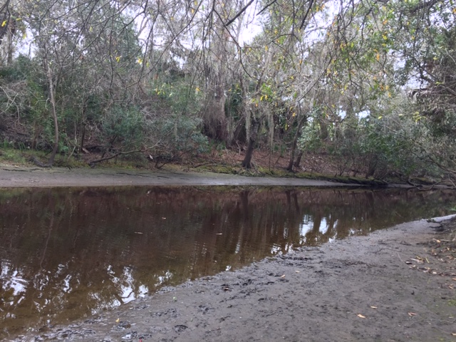
We explored a short, unmarked footpath that led to a sandy, muddy bank. The animal tracks along the wet bank were abundant. Our imaginations went wild as we saw large paw prints. Were they evidence of the elusive Florida Panther? We heard crackling in the woods and were convinced that we would get a glimpse of the majestic meat eater. Like the banks of the Myakka River, our excitement overflowed.
Slowly we realized the mysterious noises in the woods were a round of Robins dining on the berries of the bush. It was only after we went to the Florida Fish and Wildlife website, that we realized our stunning panther footprints may be those of another animal. Nevertheless, both the young and old delighted in this awesome adventure. You can help us decide who left these tracks by going to:

Who left these tracks? What do you think?

After lunch, we continued along the trail. As we meandered past markers 16 and 17, the landscape opened up a bit. A few weathered and worn pine trees waved in the distance. Two pileated woodpeckers captivated us with their calls as they cruised from limb to limb. We walked around this open area to marker 20, which did not have an outlet. Nevertheless, it was a great opportunity for bird watching.

We were thankful that trail markers 21, 22, 23 came quickly as it was muddy and the mosquitoes were hungry. We picked up our pace, and before we knew it, reached the end of the trail. With plenty to talk about, we headed back across Border Road to the parking.
This is a free park with no entrance or parking fees. While it is accessible to most visitors, there are some roots, grassy spots, and obstacles along the way, so the trail it is not suitable for wheelchairs or strollers.
The Bottom Line is: this is a great place to spend a few hours and have an outdoor adventure.
Sleeping Turtle Preserve is located at: 3462 Border Road, Venice, Florida 34292
Look for the Sleeping Turtles Preserve North sign. The park in split by Border Road into two sections. Parking for both sides of the park is located just past the Sleeping Turtles Preserve sign. It is important to note that the park is Dog friendly ONLY on the section with parking. (The Ligon Family Conservation Area). The other side, (the Rohlwing section) does not have parking and does not allow dogs.
One thought on “Family Day Hike at Sleeping Turtle Preserve North”
Wow this reads like an adventure book. Was that a bear print? Need to know.
Comments are closed.